Academia and municipalities join hands to catalyze rural environmental and cultural landmarks development
Called Baldati Bi’ati, the three-year-old project was developed by the AUB Nature Conservation Center (NCC) with the support of the Ministry of Interior and Municipalities and Coca-Cola foundation and the participation of more than 435 local inhabitants.
It tapped into villagers’ knowledge and enthusiasm to create maps with icons that pinpoint points of interest that are of value to the villages themselves and would potentially attract visitors to the area.
“The beauty of this project is that it allows the actual inhabitants of towns and villages to decide for themselves on what to preserve and how to go about it in their own regions,” said Salma Talhouk, professor and associate dean of AUB Landscape Design and Ecosystem Management. “AUB only acts as a catalyst without interfering in any way with the locals’ decision making.”
By relying on well-known scientific methodologies and involving the communities, Baldati Bi’ati succeeded in producing a sustainable and successful project that helped municipalities in planning and over the long-term enhances inhabitants’ participation in municipal decision-making.
The Baldati Bi’ati project methodology was based on an MS thesis by Lama Tawk for a master’s in environmental sciences ecosystems management in which she addressed the importance of allowing local inhabitants, rather than external experts, assign value to the assets found in a their village.
“What we actually did was get in touch with the various towns and localities, through their municipalities, schools, NGOs and civil societies to form resident committees to decide what is it they wanted to do regarding their area and environment,” said Talhouk. “We did six periodic visits, in the span of a year, for each town to allow them to develop their own plan for their area, and what exactly they wished to preserve and develop.”
As a result, villages came up with nearly dozens of points of interest that included natural assets, such as hiking trails, scenic routes and traditional agriculture, or cultural or touristic assets, such as heritage or religious sites, museums, artisanal workshops, or restaurants. AUB researchers then categorized these points of interest into nearly 80 internationally-recognized icons, based on what’s called the Open Green Map system, and then pinpointed them on aerial maps provided by the Lebanese Army.
Previous research tended to concentrate on only one physical component, such as water, built areas or flora; and on one value such as landscape aesthetics. Tawk’s thesis showed how difficult it is to understand local people’s designated and desired values as opposed to an outsider expert’s evaluation process based on the complexity and changeability of the terrain.
The engagement and participation of local communities in their region’s landscape planning and green map creation led to decentralizing the process of preserving local biodiversity.
“In this manner, the sustainability of the undertaken projects is guaranteed as the residents consider it their brainchild and ‘baby’ and will not abandon or leave it in disrepair,” noted Talhouk.
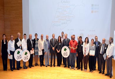
To reward villages’ outstanding achievements in biodiversity conservation, AUB-NCC, with the participation of the Ministry of Interior and Municipalities, Ministry of Tourism and Coca Cola Foundation, organized the Baldati Bia’ati Biodiversity Village Awards Ceremony and Maps Exhibition, on October 11, 2014 at the Charles W. Hostler Center,
The 2014 winning villages were: Bentael, Mount Lebanon for preserving natural heritage through local cooperation with the reserve located at the heart of the community creating an opportunity for common social activities and a potential source for income generation; Ehden, North Lebanon for sustainable highlands management in creating green jobs and ensuring that the nature reserve remains vital and dynamic with the establishment of charming small stone houses at strategic locations to monitor fires and ward off trespassers and to extending the forest cover in the nature reserve by constantly reforesting degraded areas; and Mokhtara, Mount Lebanon for preserving old agricultural terraces and footpaths to access the lush riverbanks which are equipped with a wastewater treatment plant, traditional agriculture and an eco-tourism route that encourages a positive hiking experience through maintained and mapped footpaths and archeological stone bridges.
The 2014 environmental leadership award went to Bechara Salemeh from Chahtoul, a popular camping destination, for the sustainable use of religious lands and his private initiative in arranging a long-term rent from the convent and securing 30,000m2 camp site in a forest perched at 1000 meters altitude, and with the camp site managed sustainably with low energy consumption and zero waste.
The event was also an occasion to reaffirm the partnership between the AUB-NCC and the Ministry of Tourism within a community-based tourism orientation in the framework of the National Rural Tourism Strategy for Lebanon, and to launch the villages’ tourism maps along with the maps mobile application.


